The dates and location for next year’s FOSSGIS conference have been announced. The 2024 edition of the German-speaking gathering of open-source builders and users in the geospatial space is scheduled for 20 to 23 March 2024 and will be hosted by the TUHH in Hamburg.
The call for papers is usually opens towards the end of the year and tickets usually go on sale early in the new year.
The GeoParquet community is pleased to announce the release of GeoParquet 1.0.0. This is a huge milestone, indicating that the format has been implemented and tested by lots of different users and systems and the core team is confident that it is a stable foundation that won’t change. There are more than 20 different libraries and tools that support the format, and hundreds of gigabytes of public data is available in GeoParquet, from a number of different data providers.
GeoParquet is one of the most promising geo-data formats introduced in the last few years. It adds ability to encode geographic geometries in Apache Parquet.
GeoParquet’s adoption is growing, some big names are already offering data in GeoParquet:
We’re also starting to see data providers like Microsoft, Maxar, Planet, Ordnance Survey and others put new data in GeoParquet. And the community is also converting a number of interesting large scale datasets like the Google Open Buildings and Overture Maps data to GeoParquet on Source Cooperative.
The GeoParquet community will now take the specification through the OGC’s standardisation process, which won’t fundamentally change the current specification but it will add a formal stamp of approval.
DuckDB is a database management system for data analytics that has picked up steam in the recent months within the geospatial data community.
Chris Holmes documents his experiences with DuckDB and explores its potential for work with geospatial data:
I’m not the type who’s constantly jumping to new technologies and generally didn’t think that anything about a database could really impress me. But DuckDB somehow has become one of the pieces of technology – I gush about it to anyone who could possibly benefit.
There’s a lot to love about DuckDB: Its performance, its early support support for geospatial queries and data formats (although not fully mature), and smart extensions to SQL.
What sets it apart is DuckDB’s support for cloud-native operations via the httpfs extension and Parquet:
DuckDB also has the ability to work in a completely Cloud-Native Geospatial manner – you can treat remote files just like they’re on disk, and DuckDB will use range requests to optimize querying them.
In geospatial, we’re often dealing large data sets that are har to store and explore with traditional tools, unless you import the data into a database. But it’s not just going to make data access and processing easier on your computer. There’s also a great potential to move more large-data processing into the browser:
It’s not just that DuckDB is a great command-line and Python tool, but there’s also a brewing revolution with WASM, to run more and more powerful applications in the browser. DuckDB is easily run as WASM, so you can imagine a new class of analytic geospatial applications that are entirely in the browser.
The 8.0 release brings several API simplifications. Some of them are not backwards compatible, so make sure to read the upgrade notes. The new StadiaMaps source replaces the Stamen source, because Stamen no longer hosts map tiles. Several WebGL improvements are also part of this release. And finally, a new loader API for image layers makes working with non-tiled raster data more modular and faster.
My colleague Wille Marcel looked at Overture’s data quality, specifically considering the confidence score that is included in the data:
This analysis shows that the Overture Places dataset can be quite useful when filtered by a 0.6 confidence threshold. The main quality issues we observed are the inaccurate location of many items and outdated places.
This matches my experience with the data. In my area, the location accuracy could be better; many businesses are located outside their buildings, in the middle of the road, the backyard, some even on the beach. And the data includes some businesses that have since closed.
Ahead of Google Cloud Next 23, the company announced new map data sets available through the Google Maps API.
Now we’re expanding our sustainability offerings with new products in Google Maps Platform. These products apply AI and machine learning, along with aerial imagery and environmental data, to provide up-to-date information about solar potential, air quality and pollen levels. With this technology, developers, businesses and organizations can build tools that map and mitigate environmental impact.
The SolarAPI helps building owners and developers estimate potential energy savings by leveraging solar power. Using imagery, LIDAR data and 3D models, the data provides insights on the solar potential of a building and aids the design of solar systems. The data covers 40 countries.
While data from the Solar API can help tackle the causes of climate change, the Air Quality and Pollen APIs help humans mitigate its effects.
Based on a model that takes in land cover, climate data, pollen-production rates from various plant species, the Pollen API provides estimated pollen counts for 15 plant species in 65 countries. The Air Quality API combines data from various sources, including “government monitoring stations, sensors, models, meteorological data, satellites, land cover, and live traffic information,” to create a air-quality layer covering 100 countries.
James Killick collecting some damning anecdotes about the quality of crowdsourced data on Google Maps.
There are unregistered Taxi services listed at Heathrow airport.
Upon that I was shown a Google map of LHR Terminal 5 with an icon for “Bob’s Taxis” right there in the middle of the arrivals area. Not good.
[…]
Yes, dear readers, the dreaded unlicensed taxi cab service is still there. It’s no longer called “Bob’s Taxis” and it now sounds a lot more official, but hey — I pity the poor passengers that fall for this.
After a minute the line broke up, but they called me back… from the number +33-4-56-38-67-82 (French number that came up as DTI Publishing in Caller ID). First Red flag. He had a very strong Indian Accent (Red Flag), and was overly eager to help me
I usually try to find critical information on the business’ website instead of Google Maps; not because of scammers but because I don’t trust that businesses update their information on Google Maps.
I’ve been using Apple Maps for a while now for my personal way finding needs and I’ve had only positive experiences. So far I’ve never encountered incorrect information and the map is less littered with irrelevant data.
Chris Holmes announced the imminent finalisation of the GeoParquet 1.0 specification with the release of the 1.0 release candidate.
Our objective is to launch GeoParquet 1.0.0 at the beginning of September, unless we hear any critical feedback. So this is a great time to try it out and make sure it works with your tools. Please do let us know if you add support to a new tool or make a new GeoParquet dataset, so we can add you to the 1.0.0 release announcement.
Stamen won’t be hosting their iconic and very popular map tiles any more. Instead, Stadia Maps will host Stamen’s maps tiles going forward:
We’re partnering with Stadia to move our tiles to their servers, and working closely with them to make sure that our beloved map styles keep running well into the future, and better than ever. They’re experts in running well-maintained map serving infrastructure. For most users, switching over will be as simple as setting up a Stadia account, and changing a few lines of code. For most non-commercial customers, there’ll be no service disruption, no tracking, and the price tag will continue to be free.
Stamen’s tile service will be discontinued in October; until then existing tile URLs will redirect to Stadia’s servers.
What this means:
You’ll need a Stadia Maps account.
You need to point your application to the Stadia URLs by October.
You might have to pay if you’re application serves more than 200,000 tiles per month or if you’re using the tiles with a commercial application.
All Stamen map designs will be ported to Stadia, and most styles are now available as Vector tiles too.
Considering Stadia’s generous free tier this is a fair compromise. Stamen generously made their tiles available for free for a very long time. Running a tile service needs people and the infrastructure costs money, and we can’t take it for granted that a small cartography shop provides an essential service for free forever.
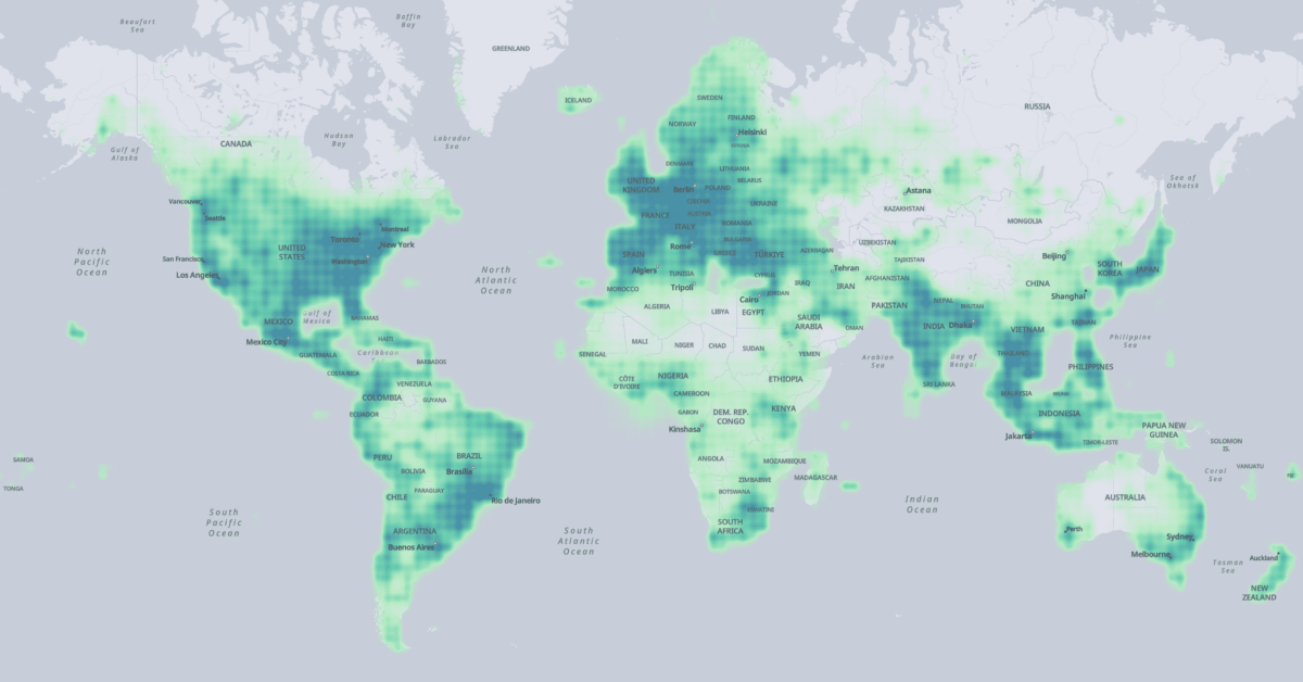
The extent of the Overture Map Foundation's places data across the globe. (Source: Overture Map Foundation)
The four layers combine data from different sources into one uniform data schema. The data has been sourced from commercial data provides, all members of the foundation, and and OpenStreetMap:
Meta contributed to places of interest,
Microsoft contributed to places of interest and buildings,
Esri contributed to buildings, and further
Buildings and transportation data was sourced from OpenStreetMap.
Accordingly the licenses vary for each data layer:
Places of interest and administrative boundaries are licensed under CDLA Permissive v2.0; the data can be modified and shared as long as the original license is included.
The buildings and transportation layers are available under ODbL, which the same as OpenStreetMap’s license.
The data is hosted on AWS S3 and Azure Blob Storage and available for download in the Parquet format, a cloud-native format. You can download the data to your local machine using the AWS CLI, Azure Storage Explorer or the AzCopy.
Alternatively, to make use of Parquet’s cloud-native capabilities to download only the data you need, you can fetch data via SQL queries in AWS Athena, Microsoft Synapse, or DuckDB.
The data release is the first major sign that the the Overture Maps Foundation is alive and produces results. Combining sources from major providers could yield one of the most complete and up-to-date data sources we currently have; it would be interesting to see how it compares to OpenStreetMap. Plus the use of modern, cloud-native formats make this vast dataset manageable, without clogging up your hard drive.